


“The terrible thing is that the situation is going to worsen over the course of the next 24 hours, particularly later this afternoon and into the evening tomorrow. So once again, we’re asking people to be as prepared as they possibly can be.”
Authorities urged people to move their cars away from large trees as heavy rain hit saturated ground and fierce winds began to tear down branches and powerlines, cutting power to 30,000 people across the Hunter, Central Coast and Sydney, as of Tuesday night.
Although much of the coast was on alert for minor to moderate riverine flooding, flash flooding unleashed by possible downpours of 200 millimetres posed the greatest threat, particularly between Newcastle and the Illawarra.
Fishers brave dangerous conditions in Newcastle as the fierce coastal low sets in.Credit: Dean Sewell
The South Coast will encounter the greatest risk from flash flooding as the weather system continues its poleward crawl before spinning into the Tasman late in the week.
“The most intense impacts, including the heavy rainfall, are most likely across the Illawarra and parts of the South Coast [on Tuesday night],” said Miriam Bradbury, a senior meteorologist at the Bureau of Meteorology.
What is a ‘bomb cyclone’?
Meteorological jargon used to describe the unusual low-pressure storm system has included “bomb cyclone”, “bombogenesis” and “explosive cyclogenesis”.
These terms all refer to the rapid intensification of the weather system. A dramatic plunge in pressure – about 20 to 30 hectopascals over the past day or two – transformed the low into a severe storm system. Regions of low pressure in the atmosphere funnel air upwards, which triggers the development of storm clouds and powerful winds.
The system the bureau called a “vigorous coastal low” spiralled down the coast while generating storm-force offshore winds comparable to a category two cyclone, adjunct professor of environmental geography at CQUniversity Steve Turton said.
“That’s certainly going to increase the wave energy and the swells and so on coming onto the coast. We’re looking at over 5 million people likely to be affected by this system,” he said.
Abnormally warm water off the NSW coast helped fuel the rapid intensification, Turton said. Warmer oceans turbocharge storm energy and supply weather systems with moisture for heavy rain.
A region of ocean water brewing 1 to 3 degrees above the long-term average also contributed to Tropical Cyclone Alfred and May’s flood disaster, Turton said.
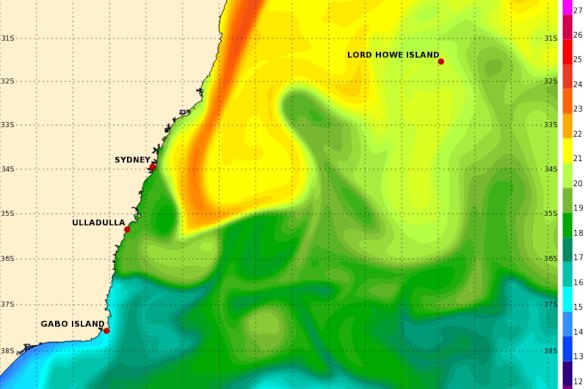
Warm water stretching down the East Australian Current on Tuesday was one of the ingredients behind the state-spanning weather system.Credit: Bureau of Meteorology
“That pool of warm water off the coast will certainly be providing additional energy into this system and increasing the risk for more rapid intensification and flash flooding,” he said.
About 90 per cent of the Earth’s extra heat caused by the burning of fossil fuels is trapped within the ocean, he noted.
NSW East Coast weather warnings
A severe weather warning for damaging, locally destructive winds remained in place for Sydney, the Illawarra, and parts of Mid North Coast, Hunter, South Coast, Central Tablelands, Southern Tablelands, Northern Tablelands and Northern Rivers as of 4pm Tuesday.
Rock fishers, boaters and swimmers were urged to stay away from the ocean under a hazardous surf warning in place from the Hunter down to Eden. Coastal erosion and damage to infrastructure may strike the coastline between Seal Rocks and the NSW-Victorian border.
Southern parts of the Mid North Coast, the Hunter, Sydney-Illawarra Coast and Snowy catchments were under flood watch for minor flooding, while moderate flooding was possible for the Hawkesbury-Neapean.
Stay up to date with warnings here or on the Hazards Near Me app.
Public transport warnings and flight cancellations
Transport for NSW operations management executive director Craig Moran advised people to avoid non-essential travel, and if they did need to travel, to give themselves extra time and be prepared for disruptions.
“There may be sudden road closures or there may be sudden delays on the public transport system. Everything is holding up OK at the moment, but … just be prepared that circumstances can change,” he said shortly after midday on Tuesday.

Delayed aircraft line up to take off at Sydney Airport on Tuesday.Credit: Wolter Peeters
A number of low-lying roads were closed in the Shoalhaven area on the state’s South Coast, which had received high amounts of rain overnight, he said.
Sydney Airport switched to using just its east-west runway on Tuesday afternoon due to strong south-westerly winds, leaving two of its three runways closed.
The agency said delays are expected, with passengers advised to check with their airlines regarding any changes to travel arrangements.
Qantas and Virgin cancelled dozens of flights in and out of Sydney on Tuesday.
Start the day with a summary of the day’s most important and interesting stories, analysis and insights. Sign up for our Morning Edition newsletter.
Read the full article here


