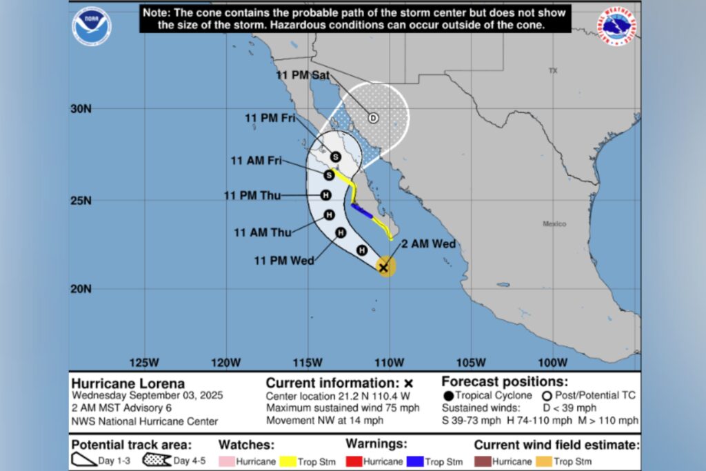
Forecasters continue to track Lorena after the system strengthened into a hurricane on Wednesday.
Why It Matters
Lorena is the 12th named storm of the eastern Pacific hurricane season. It is also the second hurricane currently swirling in the eastern Pacific, the other being Hurricane Kiko—located southwest of Lorena at the time of writing.
The National Oceanic and Atmospheric Administration previously indicated that a below-normal season was likely for the eastern Pacific, with 12 to 18 named storms, five to 10 hurricanes and two to five major hurricanes.
What To Know
The National Hurricane Center said heavy rains were expected to begin affecting Baja California Sur by Wednesday and southwestern Sonora on Thursday.
The storm is also projected to contribute to heavy rainfall in Arizona from late Wednesday through Friday.
Officials caution that the deluge could trigger life-threatening flash floods and mudslides, particularly in areas of higher terrain. In Arizona, isolated to scattered flash flooding events are possible through Friday, the agency said.
The NHC reported that Lorena had the potential to intensify rapidly through Wednesday while remaining offshore. However, it is expected to weaken as it approaches the Baja California peninsula on Thursday and Friday.
Despite the anticipated weakening, the NHC said tropical storm conditions remained possible along portions of the west coast of Baja California Sur.
“The rainfall from Lorena will be very track dependent. If the storm moves inland (like is currently forecast) heavy rain can spread across southern Arizona, southern New Mexico and even into western Texas,” AccuWeather lead hurricane expert Alex DaSilva told Newsweek. “This can lead to flash flooding in some locations.”
In an update on Wednesday morning, the agency said the hurricane was located about 120 miles south-southwest of Cabo San Lucas, Mexico.
The agency reported that it was moving northwest near 14 mph, with maximum sustained winds near 75 mph.
“On the forecast track, the center of Lorena is expected to move parallel to the west coast of the Baja California peninsula today and Thursday and then approach the coast Thursday night and Friday,” it said.
The NHC added: “Rapid strengthening is forecast through tonight. Fast weakening is expected to begin on Thursday, and Lorena could weaken back to a tropical storm by Friday.”
What People Are Saying
AccuWeather lead hurricane expert Alex DaSilva told Newsweek: “There is also a scenario where the storm never makes landfall and just slows down off the west coast of Mexico and falls apart over the cooler water. While this scenario would bring less rain to the U.S., some rain would likely still get pulled into the Southwest.”
Meteorologist Chikage Windler wrote on X on Tuesday: “The storm is expected to become a hurricane, weakening inland in Mexico. Some of the remnant moisture could bring us rain this weekend.”
Weather analyst Ryan Hall wrote on X on Tuesday: “Tropical Storm Lorena strengthening in the Eastern Pacific with 45 mph winds. Expected to become a hurricane (80 mph) by Wednesday before approaching Baja California Sur, Mexico late week. No direct U.S. impacts expected, though moisture from the remnants could eventually enhance rainfall in the Southwest.”
What Happens Next
The NHC issues regular forecast updates on its website and social media channels.
Read the full article here


