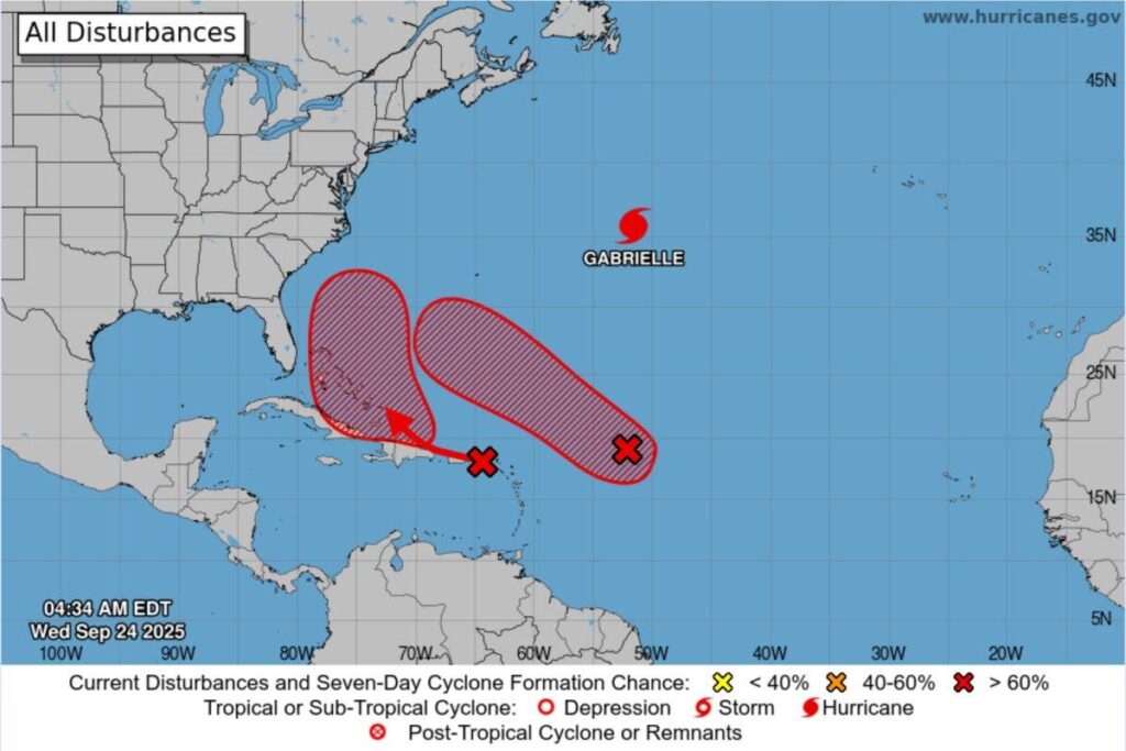
Forecasters are monitoring two spots in the Atlantic Ocean with a chance of cyclone formation, as spaghetti models shared by meteorologists reveal what paths these systems could take, with one potentially skirting the southeastern U.S.
Why It Matters
Both disturbances were given high chances of cyclone formation in the coming week by the National Hurricane Center (NHC).
What To Know
As of early Wednesday, meteorologists were monitoring two disturbances in the Atlantic, dubbed Invest 93L and 94L. An Invest refers to a weather feature being watched by the NHC for potential tropical cyclone development.
Spaghetti models—computer models that illustrate potential storm paths using meteorological data—suggested that Invest 94L could possibly track close to the southeastern U.S. from Florida to the Carolinas, while 93L could follow a northwestern path further out to sea.
According to an update issued by the NHC early Wednesday, shower and thunderstorm activity associated with Invest 93L—located around 700 miles east of the Leeward Islands—continued to show signs of organization.
“Environmental conditions are forecast to be favorable for further development, and a tropical depression is likely to form during the next couple of days while the system moves west-northwestward to northwestward into the western tropical Atlantic, well north of the Leeward Islands,” the agency said.
It gave a “high” 80 percent chance of cyclone formation through 48 hours, and 90 percent through seven days.
As for Invest 94L, the NHC said a tropical wave over the northeastern Caribbean Sea continued to produce a large area of disorganized showers, thunderstorms and gusty winds across much of the Windward and Leeward Islands.
The wave was expected to move west-northwestward at around 15 to 20 miles per hour, bringing heavy rain and winds to Puerto Rico, the Virgin Islands, and the Dominican Republic on Tuesday.
The NHC said it is then expected to slow down and shift northwestward as it reaches the southwestern Atlantic in the next couple of days.
“Environmental conditions are forecast to be more conducive for development late this week and weekend, and a tropical depression is likely to form when the disturbance is in the vicinity of the Bahamas,” it said. “Interests in the Virgin Islands, Puerto Rico, the Dominican Republic, the Turks and Caicos Islands, and the Bahamas should monitor the progress of this system.”
This disturbance was given a 30 percent chance of formation through 48 hours and 80 percent through seven days.
Should either of these systems intensify into a named storm, the next names on the list for the 2025 Atlantic hurricane season are Humberto and Imelda.
What People Are Saying
Meteorologist Bryan Bennett said on X, Tuesday: “TWIN STORMS are developing in the eastern Caribbean. Invest 93L & 94L pose a challenging forecast for the models.
TWO SCENARIOS:
- The stronger storm dominates, with the Fujiwhara Effect allowing it to absorb the weaker.
- Both remain far enough apart to develop independently.
KEY CONCERN:
- Invest 94L, the western system, bears close watching. If it consolidates, guidance suggests a possible track close to the Southeast U.S., from Florida to the Carolinas.
No immediate threat, but conditions will be monitored closely in the coming days.
Meteorologist Ryan Maue said in a post on X, Tuesday: “High chance of both Invest 93L & 94L developing into hurricanes with a risk to the U.S. East Coast from one of them. Major intensity on table for both.”
What Happens Next
Forecasts are subject to change, and the NHC issues regular updates on its website and social media channels.
The Atlantic hurricane season began on June 1 and runs through November 30.
Read the full article here


