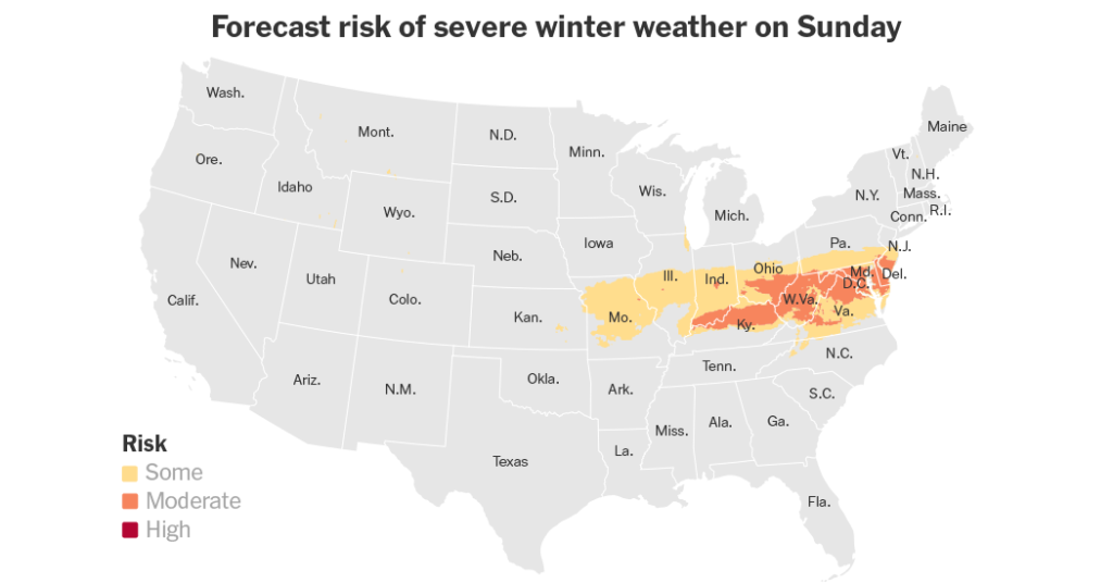
A fierce storm barreling across the country toward the Mid-Atlantic pounded a vast area with a wintry mix of sleet, snow and freezing rain that the Weather Prediction Center warned could bring “significant disruptions” to daily life and travel on Sunday and Monday.
The storm glazed roads in ice across Kansas on Saturday. The effects of the storm are expected to stretch more than 1,500 miles across a dozen states, from eastern Colorado to Maryland and Delaware.
Some 50 million people will be under winter weather advisories, watches and warnings over the course of the storm.
Power outages, downed trees and travel disruptions at airports and on roads are likely.
In the most extreme situations, whiteouts fueled by blizzards or blizzard conditions could make roads impassable and strand drivers, the National Weather Service said.
Several states in the path of the weather system — including Arkansas, Kentucky, Missouri and Virginia — have declared states of emergency, and Maryland declared a state of preparedness. The declarations are intended to improve the states’ responses to the storm through various means.
Gov. Eric Holcomb of Indiana planned to activate the National Guard to help with any highway rescues, said Jane Jankowski, his deputy chief of staff.
The storm is hitting as arctic air from Canada seeps into the United States.
As the storm system pushes offshore on Monday, “brutally cold” air will settle behind it, said Bob Oravec, a meteorologist with the Weather Prediction Center.
On Tuesday morning, many locations will be faced with roads covered in snow and ice, including Washington, D.C., where a procession is planned as part of Jimmy Carter’s funeral.
Heaviest snowfall in a decade expected in some spots
Nearly four million people across much of Kansas and Missouri were under a blizzard warning early Sunday that was scheduled to last until 3 a.m. on Monday. Some locations were forecast to receive the heaviest snowfall in a decade.
Forecasters warned of wind gusts of up to 40 miles per hour and between eight and 12 inches of snow. Blizzard warnings are issued when heavy snow and wind speeds of 35 miles per hour are forecast for three hours or more.
As a low-pressure system swept through Kansas and Missouri overnight, dozens of highway crashes were reported.
“The snow has not arrived, but we’ve got ice and it’s building up, still causing difficulties,” Trooper Ben Gardner of the Kansas Highway Patrol said in a video on social media. “Stay home, especially tomorrow. The snow’s going to arrive and you don’t want to be out here because it is brutal.”
In northern Kansas, a 100-mile stretch of Interstate 70 was closed overnight, according to the authorities. Plows would be out through the night, said Kim Stich, a spokeswoman for the Kansas Department of Transportation.
In Kansas City, Kan., Brock Graham, the manager of Chateau Avalon Hotel Spa and d’Nile Lounge, a boutique hotel off Interstate 70 in the western outskirts of the city, said that most of the hotel’s employees had been sent home for the weekend.
The hotel expected only a few guests after a wave of cancellations. Those who stayed to work would not go home until Monday, Mr. Graham added.
“It’s going to be difficult or nearly impossible to drive,” Mr. Graham said, adding that shelves on nearby grocery stores were mostly bare. “I think everyone in the area is preparing.”
The storm is forecast to bring snow to the Mid-Atlantic
On Sunday, the system was pushing from Missouri and the lower Mississippi Valley into the Ohio Valley.
In an elongated area between northeast Missouri and the central Appalachian Mountains, heavy snow is expected with snowfall totals of eight to 14 inches from Saturday into Sunday and Monday. Southern Illinois and Indiana are predicted to get hit with a couple of inches of sleet.
In Ohio, where the storm was expected to lurch into hilly areas in the southeast portion of the state, thousands of miles of roads had been treated with salt by Saturday, said Matt Bruning, a spokesman for the Ohio Department of Transportation.
The state expected to deploy more than 1,000 snowplows at the height of the storm, he said. Clear, sunny weather was helping Ohio in its preparations on Saturday.
“Now, it’s just waiting for Mother Nature to bring whatever she brings,” Mr. Bruning said.
To the south of the band of heavy snow, a stripe of freezing rain is predicted to fall from central Kansas into the central Appalachians through Monday, according to the Weather Prediction Center.
“That rain will freeze on contact and turn to glazing — that’s what sticks to the trees, power lines, roads, cars, car windows, everything,” said Rich Bann, a meteorologist with the Prediction Center.
After crossing the central Appalachian Mountains, most likely early on Monday morning, the system will move into the Mid-Atlantic.
By daybreak Monday, snow will be falling across a large portion of the Mid-Atlantic — including Virginia, Maryland, Delaware and Washington, D.C., and it is expected to continue through the day.
Baltimore is forecast to get four to eight inches of snow and Washington, D.C., five to eight.
If the system shifts slightly north or south, the totals could go up or down “quite significantly in either direction,” said Kevin Rodriguez, a forecaster with the Weather Service.
By Tuesday, the snow will have ended in the Mid-Atlantic, but cold, gusty weather is forecast through the week, with afternoon highs in the 30s in the capital, and overnight lows in the 20s.
“The snow on the ground that falls, it’s not going to go anywhere because it will be so cold,” Mr. Rodriguez said. “You’ll have snow on the ground all week.”
Yan Zhuang contributed reporting.
Read the full article here


